Showing posts with label great basin. Show all posts

Sunday, November 21, 2010

Fall In The Desert

It has been awhile since posting, but I am back to put up some new pics.  The desert takes on a new look in the winter, especially the Great Basin and the Colorado Plateau.  Above are the south side of the Uinta Mountains that rise above the Uinta Basin in northeastern Utah.

On the Utah County and Tooele County line in western Utah is five mile pass. This picture is on State Road 73 just west of Fairfield, Utah at sunset. The days are short in the fall and winter, but some of the best sunset pictures can be obtained due to the angle of the sun.

Yes, we do have some color in the area. Here is a fall shot of some trees at Temple Square in Salt Lake City, Utah. Indian Summer or late September and October can produce some of the most beautiful fall color combinations.


Many flowers that are very cold hardy last well into the fall and it takes several frosts before the flowers will finally die back for the oncoming winter.


Up in the high mountains the browning of the grasses contrasts greatly against the deep blue waters of Strawberry Reservoir on the back side of the Wasatch Mountains in Utah.
The Alpine meadows near Park City, Utah show a variety of colors as evergreen pines contrast against the Aspens. Only 20 miles to the east the Valleys are still a few weeks away from full fall color.

Finally just seeing the contrast of the seasons is one of the beauties of the seasonal "cold" desert areas. Many different elevations and climates produce a variety of photographic experiences that would not necessarily be seen in the deserts further south in the United States.

Tuesday, August 31, 2010

The Wide Open Road


Sometimes life is just about taking to the road and seeing where the road will take you.  The desert road trip can be different in many ways.  Sometimes the paved road gives way to the dirt road. And the dirt road takes you off the beaten path.  There is always something special about hitting the road in the desert.

During the spring in the Mojave you just might find the greatest of all yucca, the Joshua Tree in bloom. The long stocks of off white flowers reach toward the sky. At night the yucca moths pollinate the yucca flower enabling the plant to fruit.

The off beaten path may lead you to bizarre rock formations such as this one in the Mojave. Colors of red, orange hues contrast against the chocolate brown mountains in the distance.

In the Autumn you may find yourself looking at the changing colors of groves of trees preparing for the long winter against the high mountain peaks of the Rockies that form the boundaries of the Great Basin, Colorado Plateau, and Chihuahuan Deserts.

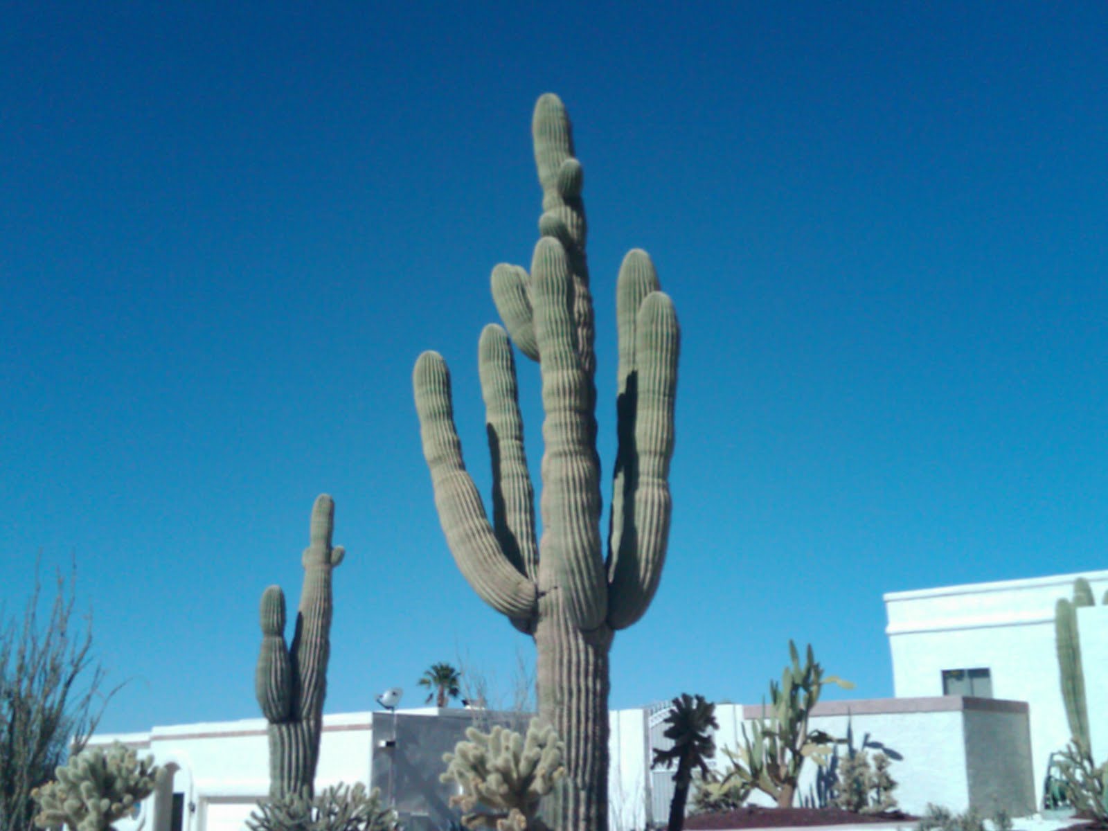
If you are passing through Las Vegas you may see a grand Saguaro cactus out of its native environment in southern Arizona and planted in someone's front yard.

If you happen to be in southern Utah just outside of Kanab you may see the Coral Pink Sand Dunes and the State Park with the same name. These dunes are formed from the colorful Navajo sandstone that is the predominant rock of the area. These dunes are famous for their beauty and for their appeal to the off road vehicle enthusiast.

Or you just may be stopping over at an outpost somewhere along a state line such as this little area called Border which sits in both Utah and Nevada along US 6 between Delta, Utah to the west and Ely, Nevada to the east.  Wherever the road takes you may you have a new adventure each time and enjoy what is around you.

Saturday, August 14, 2010

Never Allow Dave and Kirk On A Road Trip


When Kirk and I go on road trips we can be hazardous to the public.  Kirk is more mellow and reserved. I am just whacked out. Put us together and we are hell on caffeine.  Kirk is a nice guy and then I come around and he becomes a different creature from those who claim to know him as the nice guy at the government.  Kirk showed me this palm at Wal-Mart. This is a needle palm. Found it for $20.  It now sits in my yard. Thanks buddy. It was his passive aggressive behavior that led me to by this one.

This next photo I could not bring over so I linked to it. When we stopped in Green River, Utah we caught this dude filling up his plane at a gas station.  He said he was from Eagle Mountain, Utah. What ever floats your boat.


To the left is the Gieco Gecko or something like that. Kirk had to get a shot of this lizard while I wanted to run naked through the brush of the Book Cliffs.  Of course with not willing to put up with my antics Kirk took this photo and threatened to leave me behind. Fine, whatever dude!

Kirk always wanted his photo taken somewhere cool. When we were at Antelope Island in Utah we went into this old ranch house. Kirk thought that he would look bitchin next to this old phonograph. Now I admit this is not exactly a desert photo at first glance.  But it was taken inside an old shack in the desert so don't give me any grief. Note the camouflage fatigues don't go with the coat.

Now some people do not believe that me and Kirk are actually environmentally friendly. This is not true. It is true that I like fossil fuels burning amass producing electricity.  Kirk, I am not sure what he actually likes to see mechanical wise, but I digress.  In this link you can see us actually hugging a tree. It is a beautiful trunk isn't it. The dude couldn't get his damn finger out of the way ruining the true effect. I tried to get Kirk to hug me, but he declined. No sense of humor!

This again is at Antelope Island. Notice the green bog in
to the right. This bog was still nice and green well into November 2009. Now if you don't think that we don't just stumble across the most beautiful places on earth then you have no sense of imagination and you don't know Kirk and Yours Truly.  We both agreed that a swim in the bog was not on the adventure agenda for the day.


The Mojave Desert brings the best out in both of us. On this trip we were in Moapa, Nevada in an area known as Warm Springs.  Kirk thought that road trip means taking a picture of the road.  Ansel Adams he is not, but I have to give him credit for actually capturing some palms on either side of the road.


This lovely rock formation is at the Garden of the Gods outside of Colorado Springs, Colorado. Kirk had us hiking all over this place. He took a while finding it too. Nonetheless I got this lovely photo.  Kirk insisted that blistered our feet were we hike on.  I screamed abuse, but nobody listened. His girls just laughed at me and my teenage son refused to admit he had a father.

Finally, to end this lovely entry when I went out to Colorado last year Kirk showed us Cherry Hill State Park which is an earlier entry in this blog of ours.  But I thought it fitting to let you all know that the place is full of plains yucca.  Plains yucca go from the Front Range of the Rockies east to the boring land of the Midwest US.  At least there is something that is yucca in this post.  Had I not lost my photos of Bennett, Colorado I would have included them, but my computer crashed and the Garden of the Gods one was one of the few that I had left.

Now I wish I had more time to give you the lowdown on the odd couple relationship that Kirk and I have on road trips.  On one trip back from St. George, Utah a thunderstorm came in around Beaver, Utah. I screamed "Run for your life! Hurricane! Its the Apocalypse!" One mother and her kids got the hell out of there, Kirk nearly fainted, and I am not sure what came over me, but I am sure it was the adrenalin rush of caffeine.

Sunday, August 8, 2010

Snow Canyon State Park, Utah


Snow Canyon State Park in southwestern Utah is one of my favorite haunts. This may be one of  the great desert state parks around.  Snow Canyon sits on the intersection of where the Great Basin, Colorado Plateau, and Mojave Desert all meet.  You get an ecosystem here that blends all three deserts into one habitat.

The Park is part of a geologic oddity with volcanic activity that is only a few thousand years old, Navajo Sandstone cliffs and folds, lava fields, lava boulders, extinct shield volcanoes and dunes. The picture above is of a petrified dune.  If you look at the plants in the picture you can see Teddy Bear Cholla growing alongside juniper trees, sagebrush, and mesquite.

These large boulders are part of an older volcanic field. The orange, brown and reddish hues blend together with the with the blue green shrubbery to make the views interesting at each stop.
This is a shield volcano cone that is extinct. Try hiking the thing. It will give you a good workout to reach the almost straight up summit.

My final shot is one of my favorite that I have ever taken. It shows the contortions of the cliffs, the color of the area.  In the foreground you can see the remains of a broken up lava flow. It would have been cool to be here when the area was more geologically active.  Who knows, I might get my wish sometime.

Saturday, July 31, 2010

If Interstate Travel Bores You Things To Do While Crossing The Desert

Driving across the vast expanses of America can be very uneventful. In the Midwest and West you can go for miles and get nothing but tumbleweeds and sagebrush. So here are some helpful tips while crossing the vast expanses of land from sea to shining sea.

Always take advantage of increased speed limits.  Most states in the west have 75 MPH speeds, except Oregon, which is stuck at a maximum speed of 65 MPH. So decrease those vast expanses by taking advantage of the interstate travel speeds and rural highway speeds.  Always watch for the law and drive safely.

Notice the landscape. This is Blue Mountain in eastern Utah near Vernal. The Western US is full of varied landforms from the Rocky Mountains to bizarre landmarks. This can break up the time so you don't fall asleep at the wheel or redirect your "are we there yet" children by showing them the beauty and diversity of the geographic features while heading to Disneyland or Sea World.

Driving along the edge of a cliff will always take away boredom. Fear of falling is something we are all born with so why not use it to our advantage.  If you are afraid of falling off of a cliff like this winding road through Colorado National Monument, you will stay awake or others in the car will insist you pull over and let anyone, including the baby take the wheel so you don't plunge to your death.  Also spectacular views should keep anyone awake just for the beauty of the trip.

If you must drive across northern or central Nevada may I suggest night. Day driving can cause drowsiness even for the most experienced drivers.  US Highway 50 is the "Loneliest Road in America" for a good reason. I have seen the miles of sagebrush and junipers mile after mile in the day. A night drive and a chance encounter with alien life forms may be more to your liking. Let the night do it's magic of hiding boredom while you quickly cross the vast expanses of the Great Basin.

Summer is fire season. Why let a good bushfire go to waste if you are driving by.  Lots of other rubberneckers will also be paying attention. The fire with its large flames, the choking smoke, the planes dropping large amounts of fire retardant on the blaze all make for good learning and lessons of nature. Just don't put yourself in danger by being a gomer and getting yourself into a situation where you could become a victim of said blaze and be injured or killed.  Point out to the kiddies that when you smoke and chuck that butt into dry grass this is what might happen and the authorities may stick you with the bill for being a dumb ass for starting the fire.

Oil is the life blood of America. These big oil well pumps have always amazed me the way they pump out crude out of the ground. This one is at the foot of the Uinta Mountains in Utah. But they are all over the West and Southwest if you know where to look such as Colorado, Texas, Oklahoma, New Mexico, Utah, Arizona and even the liberal bastion of California.  For fun if you have an environmentalist wacko in your car stop on the side of the road next to the beast and just count the up and down movement of the pump. Preach about drill baby drill until they strip naked and run into the desert seeking a hippie colony to feel safe with.

If you are a fan of canyons and rivers may I recommend Hells Canyon on the Idaho-Oregon border. This geologic wonder of river erosion through rock to make canyons. Hells Canyon lives up to its name. Very hot in the summer and freezing cold in the winter. Hell is a furnace and also freezes over.  The Snake River is a great place to take that break to stretch as you take out your map to find out where the wrong turn was or why your GPS isn't working.

In the west Utah deserts as with other places of the west the monotony of boredom can set in quickly. Thus point out that you are confused as are these mountains. The Confusion Range in Juab and Millard Counties in Utah will confuse you if you get off the road. Some of the mountains appear to have been broken off and only half remain.  Shield volcanoes also litter this area for hundreds of miles north to south. So stay on the main road unless you know how to be confused.

When in doubt of where you are going consult the Ancients. Their highly visible images just might break up that long drive across the desert. This place called Newspaper Rock in southeast Utah will tell you about who invented the wheel, find game, plant corn, and where to hide if neighboring tribes come to kill you. Though the Anasazi have moved on they left this map for our generation so that long after they had gone to the Great Spirit, you could have their wisdom on your journey.

Tuesday, July 27, 2010

Ye Olde Prickly Pear


One type of cactus you can always count on is the Prickly Pear whether you like them or not. They come in all sizes from the flat pads, spines, small glochids, itchy to downright painful.  Prickly pears always are around.

From the Opuntia family these cacti are found in all the major North American deserts.  The Great Basin is North America's largest desert. And one of the few species of cacti that live there are the opuntia polycantha.

This lovely cold hardy cacti was one I encountered as a young boy in Sandy, Utah along the mountain foothills. I ran into a giant colony of them and screamed all the way home. Now I raise them, how irony changes a hate to a love.

Lewis and Clark as they came across the continent noted that the prickly pears were everywhere and they had to watch out carefully or they would step in them. The thorns went through their moccasins (OUCH!) and were a constant nuisance.

The one thing you can count on with prickly pears though is that they flower. In fact all cacti are flowering plants.  Prickly pear have a variety of blooms from crimson red, to pink, to orange, to white, and hybrids of the above. This specimen was taken at the Idaho Arboretum in Boise.  One last flower before the summer fireworks were over for the year.  Just how big can a colony get? Well that varies. I have seen them as high as six feet and wide as ten feet.  They propagate by sexual reproduction, the flower, and thus fruit and seeds, and by dropping pads. A disconnected pad will take root and start a clone of the parent plants.

I am not sure if prickly pear or any other cacti for that matter send out rhizomes, so help me out here in the comments section if you have an idea.

I can only imagine Lewis and Clark and the Corps of Discovery encountering colonies like this mile after mile. This type of large colony is not unusual in the wild if the plants are in the right area for sun, moisture, and nutrients.  They love well drained soil and that is where you will find almost all species of the prickly pear.

The last photo is from the Colorado on the Colorado Plateau. This bunch was on a cactus Wikipedia page about cacti for awhile. And then the anal retentives decided that their pics were better than mine. But this batch has made it back because the blog belongs to Dave, yours truly and Kirk the other guy who occasionally posts here. So here I will round out my blog on prickly pears for this cactus episode.  Maybe next time I will blog about Home Depot cacti, but then maybe I wont.

Monday, July 12, 2010

Great Basin Summer


It is July here at the eastern edge of the Great Basin and the foot of the Wasatch Range of the Rocky Mountains.  Typically at this time of year from late June through August temperatures range in the 90 degree Farenheit range with about one to two weeks in the 100+ degree range possible.


Now sometimes I think of the Great Basin as a very boring type of desert.  The standard shrub is the sage brush. And mile after mile of the stuff can be very boring.  However there are some very pretty areas of this large basin if you know where to look.

At the northern end of the Great Basin is the Snake River Plain a large volcanic field with fertile soils that streches from Yellowstone National Park on the east to Oregon on the west. The above picture is a sunset near Ontario, Oregon.


While making a brief trip to Wyoming before the Independence Day weekend I took a shot of the new Welcome to Utah sign. Nice to see that the state finally has the idea that the 2002 Winter Olympics in Salt Lake City are finally done. The old signs depicting the games were up far too long. Looking across through the sign you can see the typical high basin and range topography that the Great Basin is famous for along with the endless sage.


This photo shot near my home is one of those "get that shot" moments. We get thunderstorms that come in the afternoon. This sunset just happened on the tail end of one of them. This is over Lehi, Utah.


I am not quite sure what type of flowers these are but they stand out against the brownish clay ground cover.

This is another typical Great Basin Shot. Across the sage and salt brush you can see green junipers covering the higher foothill. These junipers are the primary conifer over most of the basin and range desert.

A pair of small daisies growing up near a rock covered with lichens.

Opuntia polycantha or the Great Basin Prickly Pear flowering amongst the rocks and sage.


Fish Springs National Wildlife Refuge in western Juab County, Great Salt Lake Desert, Utah.

Mountain stream near Sundance, Utah.

Thistles can look pretty with their white flowers. Don't touch and I would not recommend for landscaping.

The Wasatch Range looking east from Eagle Mountain, Utah.

Sclerocactus glaucus in bloom.

Dry Creek in Highland, Utah. Not quite so dry as this is right before rain and high tempratures caused the creek to overflow its banks. Dry Creek orginates in Alpine, Utah in the Wasatch Range and empties into Utah Lake.

This is Utah Lake with the snow capped Wasatch Range in the background. As late as June the mountains are still capped with snow that will run off well into July before the highest peaks at 12,000 feet are completely snow free. Utah Lake is one of three large lakes in Utah left behind by ancient Lake Bonneville 10 to 15 thousand years ago.

The Great Basin for its size has many interesting areas to visit. It has one National Park, Great Basin National Park, extinct volcanic fields scattered across the eastern and central desert, caves, and sand dunes are all found within the Great Basin geographical area.  Late spring and early summer the desert comes to life only to become dry and brownish again by August.  

Deserts truly are magnificent places. Beauty can be found if only one looks beyond the dryness and heat to see what life makes its home in such a challenging environment.

Cactus Ring

Powered by WebRing.